Did you hear the thunder? Did you see the lightning? That’s right, it’s summer. If you have ever lived just about anywhere else in the United States, you know that thunderstorms are not the symbolic weather phenomena of Pacific Northwest weather. In fact, they are so rare here, they often surprise us.
I want to try and explain in layman’s terms (because that’s all I really know) the conditions that create thunderstorms in our neck of the coniferous woods.
First question: Which direction does our weather typically come from?
If you were/are a student at Western Washington University, at some point you may have taken advantage of the opportunity to sit at a window seat in the Viking Union and eat lunch or do homework. The window seats look out over the Bellingham Bay, Lummi Island, and northwestern Whatcom County. It’s a phenomenal place and one of the first surprises that made me fall in love with Bellingham. Here’s a timelapse from my perch while studying for a psychology exam.
I mean, come on. What a place to do freaking homework. Or at least try…
One of the best things about that window seat facing west is that it was the perfect watchtower for incoming weather. The high, whispy cirrus clouds would begin their slow saunter, followed by the milky altostratus, then the bland stratus, and finally the gloomy nimbostratus (rain clouds) would begin their vegetable mist on the produce of people and concrete below.
The storms come from the west most of the time. The southwest, in fact, is the most common direction for storms to move in from. Lummi Island for a Bellingham resident is often the perfect landmark to keep an eye out for what the sky above will usher in next.
Most of the time, storms from the west bring the persistent light rain that is the symbolic, quintessential PNW form of weather. It’s this weather that causes us to like moody folk songs in coffee shops and only wear grays and blacks.
Most storm systems that move into the PNW are organized low-pressure systems. Have you ever heard a local weather forecaster use that term? Still have no idea what it means? It’s a spinny thing, right? Yes, it’s a spinny thing. It spins counter-clockwise. it’s typically over 1,000 miles in diameter. It called “low pressure” because air is usually moving upward within the system. Imagine, if someone is blowing air at a spot on your arm through a straw, the pressure at that spot on your arm will be higher than it would if they were sucking air through the straw. In the same way, imagine the center of a low-pressure system is the middle of a big straw with air getting sucked upwards. Things are a little more complicated (shocking, I know) than this as the air is actually spinning and it isn’t getting sucked up. Rather, it’s getting forced upward by many dynamics including differences in density in comparison to the surrounding area.
See the image below.
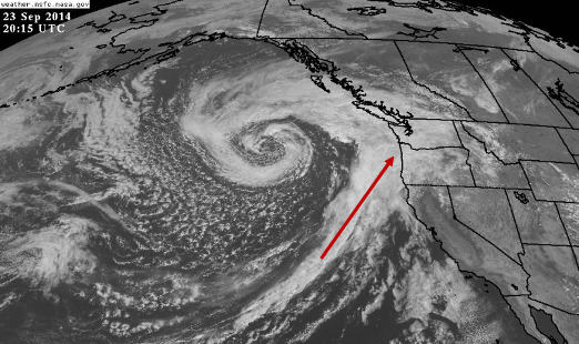
That forms on its own volition. Humans have nothing to do with making that happen. It’s awesome. A beautiful low-pressure system aimed right at the Pacific Northwest. This right here is a classic set up for endless light-to-moderate rain and low clouds.
The reason our weather is pretty mild is because these systems have just spent endless time over the Pacific Ocean, where the temperature is just about the same wherever you go for thousands of miles and the ocean is, well, flat… just like the earth. Anyway. Strong storms need sharp contrasts in temperatures, opposing and erratic winds, and bumpy terrain in order to form. The fifty feet of land that a storm crosses over before it arrives at our West Coast door is not enough to provide any kind of enhancement in conditions.
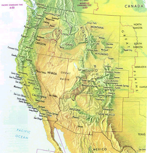
Second question: Which direction do our thunderstorms typically come from?
I had the great pleasure of getting to sit next to a meteorologist in the National Weather Service Portland office as he was tracking the development of a strong thunderstorm over central Oregon. A small cloud was forming over a mountain peak that was beginning to strengthen and spread out. Pretty quickly, the storm was far larger than the mountain, and then the cloud began to drift. Like lighting a candle and then walking it around a room, this storm eventually moved into the east Portland metro and then drifted off into the south Washington Cascades. Our thunderstorms almost always come up from the south or southeast.
What does the area to the south and southeast of us have that the area to the west doesn’t? Heat! Bumpy terrain!
Strong storms need something called uplift, which is basically what it sound like- upward winds. They need something to really force the air upwards. Hot air is less dense than cold air, so it can rise. Bumpy terrain also forces air to rise. When it rises, weird stuff happens. The upper atmosphere gets very intense with winds going up causing the air to cool down and become incapable of holding the moisture as a gas. It condenses and then water droplets bump into each other and get bigger. Sometimes they freeze and collide and get bigger, turning into hailstones. At the same time, other winds are going down some winds are spinning in circles or colliding. And our stronger storms begin to form.
The warmer the air is, the more water it can hold as well. A fun fact for you: there is more moisture in the air on a warm and humid, yet sunny summer day than there is on any rainy day in December through February. It may not feel that way, but that’s the difference in the amount of moisture than can be held in the air, depending on temperature. Heat helps strengthen storms, allowing the possibility for more moisture in bigger droplets to fall.
Today, we have a low-pressure system camped somewhere over Southern California, which is quite rare. The spinning air that rotates counter-clockwise is spinning around that low, which means it would come from which direction? See the image below (stolen from the Cliff Mass Weather Blog).
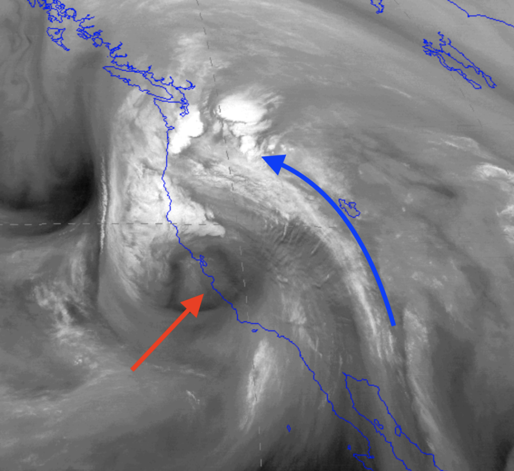
The weather is coming in from the southeast. This is often a perfect set up for thunderstorm gold. Unfortunately, I think it’s still a little too cold for these storms to really pick up on the west side of the Cascades. But they are going to be very strong over eastern Washington- Supercell thunderstorms, hailstones, lots of lightning, flash floods, 60-70 mph winds are all possible tonight.
We will probably get some heavy rains this evening and maybe hear some thunder. The south brings the wild cards and today is a fun one for the PNW. Now, go read that Cliff Mass Weather Blog if you want understand the more technical stuff.
Stuart Rafferty
May 30, 2020 | 11:11 pm
Thanks Jack Back in Tracy sitting through thunder and lightning storm in the car with the dogs whilst carolynn is getting her hair done
So this was very timely
Cheers
Shelly
May 31, 2020 | 4:57 am
And here I thought that it just went BOOM BOOM BOOM! Thanks for filling in the blanks Jack! I know you love a crazy big storm!
stephanie
May 31, 2020 | 7:03 pm
i simply love how you so eloquently teach us the fascinating aspects of weather…I learned so much in this post. Please keep them coming…thank you Jack!! Love aunt steph
Mom
June 1, 2020 | 7:09 am
Hey Jack,
I actually learned some new things about weather – particularly weather in the Northwest. Keep these coming. It’s a joy to read your thoughts.
PS: The Saturday morning storm was so great. And my flowers loved their dose of nitrogen from the lightning.
Matt McCoy
June 1, 2020 | 7:02 pm
Ah, a delight to read in detail about the phenomenon we all got to experience together!! Well done!!